Why to choose Mlilo l To do and to see l Itineraries l Excursions l Accomodation
Access to the sections :
- National parks
- Historical and cultural sites
- Hills, mountains and forests
- Ranches
- Beaches
- Uganda sites
- Local markets
Hills, mountains, lakes and forests
Shimba Hills
The Shimba Hills are a National reserve of 250 km2. It is a small National Park in the Coast Province of Kenya, 33 km from Mombasa and 15 km from the coast. With its 500m of altitude, the silence and the coolness are a nice alternative to the crowded beaches and the hit of the coast. The reserve is an area of coastal rainforest, woodland and grassland. It is an important area for plant biodiversity – over 50 % of the 159 rare plants in Kenya are found in the Shimba Hills, including some endangered species of cycad and orchids. It is also a nationally important site for birds and butterflies. On lodges’ foot, we can see buffalo and elephant herds, and even sometimes leopards. There are estimated to be approximately 700 elephants in the reserve. Shimba Hills contains Kenya's only population of Sable Antelope. There are about 100 in the park. When the weather is clear, you can see the Mount Kilimanjaro.
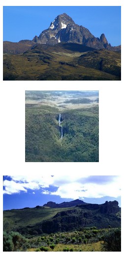
Mount Kenya
You can climb its 5200 meters high in 4-5 days and admire beautiful sceneries all the way. It is never possible for one to see Mt Kenya clearly until you get into the National Park. There are superb views over the surrounding country from Leana. The glaciers are somewhat of a geographical marvel, being just 16 km south of the equator. It is recommended that a week or ten days be put aside if one wants to enjoy their trek.
Mount Elgon
Mount Elgon sits astride the Kenyan/Uganda border and while it offers similar trekking possibilities to Mt Kenya, its location makes it a far less popular goal for people. It is the second highest mountain in Kenya, at the foot of Mt. Elgon is about 470 Km from Nairobi and has an area of 169 Km sq. The main advantage of Mt Elgon is the lower altitude means conditions are not extreme, though rains are more frequent. The mountain is an extinct volcano with a distinctive shape. The forest is an untamed wilderness that was declared a biosphere reserve by UNESCO in 20036 in recognition of its importance as a water catchment area for the Nzoia River flowing into Lake Victoria and for the Turkwel River flowing into Lake Turkana. Mt. Elgon has a wide variety of attractions that include caves formed from ancient lava tubes, cliffs and mountain peaks ideal for climbing, waterfalls, gorges, hot springs and calderas.
Taita Hills
Taita area is very famous for its national park of Tsavo. It is the biggest national park in Kenya where lions, giraffes, elephants and many other species use to live there in abundant. But more than a simple wildlife home, the region of Taita offers the opportunity to discover another face of Kenya. Forgotten for a long time since the prohibition of poaching, the Taita area is becoming back a great destination in Kenya where diversity makes that place unique. With its green hills above the sky where fruit and coconut trees grow up between farmers crops, with its dry bush neighbor to Mount Kilimanjaro, with the singularity of its inhabitant’s way of life, with its colonial history and mysterious caves Taita will bring you a unique satisfaction: the mix between wildlife observation and cultural discoveries.
Wundanyi
Wundanyi is a town lying in the Taita Hills of southern Kenya, west of Voi and near Ngerenyi. It is also the Headquarters of Taita-Taveta District. The town has a population of 4000 the centre of an agricultural area, the surrounding slopes are terraced. The town is a popular base for hiking, while local attractions include the Ngangao Forest, known for its butterflies, Wesu Rock and the Cave of Skulls. Ngangao is the second largest forest and one of the least disturbed forests of the Taita Hills. As a result, it is a stronghold for many plant and animal species. There are the three endemic birds’ species of the Taita Hills.
Ngangao Forest
Ngangao forest is a closed canopy cloud forest which is reminiscent of the rich tropical rain forest of Central Africa. It is easy to traverse due to the gentle topography of the area and well beaten paths. It is home to a variety of endemics both flora and fauna. For bird watchers it is classified as an Important Bird Area with excellent bird viewing opportunities.
Lake Jipe – Kenya, Tanzania
Lake Jipe is a small, shallow lake (area 28 sq. km and average depth less than 3 m), lying astride the Kenya-Tanzania border, just to the east of the northern Pare Mountains of Tanzania (Mwanga district, in the Kilimanjaro region). It is 12 km long and 2.5 km wide, 12 square km belong to Tanzania and 14 square km to Kenya. Tsavo West National Park of Kenya borders the southern portion of the lake while Mt Kilimanjaro dominates the horizon some distance to the northwest. Lake Jipe receives its main inflow from Mt Kilimanjaro in Tanzania via River Lumi passing through Kenya. The other main inflow is via River Muvulani from the Pare Mountains. Several temporary streams, mainly from the Pare Mountains, also drain into Lake Jipe. The lake has one outflow, the River Ruvu, located in Tanzania to the south of River Lumi, the main inflow.
Lake Naivasha
It is the highest of the valley lakes at 1880meters above sea level. It is a fresh water lake and home to over 450 species of birds including the African fish Eagle.
Lake Chala
Lake Chala - fresh water Crater Lake is a bowl – like steep depression whose source is thought to be Mt. Kilimanjaro. However, it is not yet clear where the lake drains its waters. Its edges drop steeply to about thirty meters to the bottom. A few fishermen work here using dugout canoes. It appears that many people here are involved in cross-border trade.
Ndere Island
It is just a short distance from Kit Mikaye. The park is just off the northern shore of Lake Victoria and is home to the lesser known spotted crocodiles, monitor lizards, birds and water antelopes.
Arabuko - Sokoke
It is the largest remaining section of an indigenous dry coastal forest that once stretched from Somalia to Mozambique. Regarding bird and biodiversity conservation, it has been internationally recognized as the second most important forest in mainland Africa. Arabuko-Sokoke extremely rich biodiversity supports over 270 bird species,260 kinds of butterflies, 80 different amphibians & reptiles and 50 types of mammals, including elephants and monkeys. Of the animals in the forest, there are ten species that are globally threatened or are endemic to the forest which means they’re found nowhere else on earth. The forest’s 3 distinct vegetation zones , ranging from thick coastal forest in the east to open woodlands in the west, also supports over 600 varieties of trees and plants. The site offers: Guided hikes & specialty tours like bird-watching & night walks with professionally trained local guides, Two Tree platforms with unique views, perfect spots for picnics & camping, Nyari viewpoint boost views of the forest and the Indian ocean, another great spot for picnics & camping, Seasonal pools & swamps throughout the forest are the best places to spot wildlife, Bicycling & driving trails throughout the forest, Overnight camping at public or special sites throughout the forest, Arabuko Jamii Lodge is a community lodge offering comfortable facilities right by the forest.
Gongoni Cultural Center
The organization target to the mutual understanding of the culture among youth and to appreciate the way of life: Enable Giriama people to understand and observe heir culture and traditional ways of life. Promote cultural and traditional through sensitization and popularization. Improve resultant socio-economic status of the community through culture & tradition. Encourage traditional dancers to start income generating activities. Discourage cultural & traditional attitudes that hinder socio economic development.
Hell’s Kitchen/Dakatcha Woodland/Mulunguni
This umbrella group draws members from five community based organizations (Baricho Youth Group, Mulungini Umoja Youth Group, Mahenzo Youth Group, Marafa Hell’s Kitchen Tourist Operators Association and Mulangaza Youth Group). They have come together to work for a conserves biodiversity-rich and prosperous Dakatcha.The group activities include: Establishing tree nurseries and commercial woodlands and tree planting, Beekeeping and honey processing , Creating awareness on environmental conservation issues, Conducting monthly bird watching outings, Monitoring of habitats and biodiversity, Guiding visitors.
Malindi District Cultural Resource Center
Malindi District Cultural Association is a Community Based Organization (CBO) formed in 2003 with the primary objective of reviving culture and cultural activities. Activities of the organization include inter alia: Establishment and promotion of historical/cultural sites, Promotion of sounds eco-practices, Promotion of cultural tourism, Promotion of peace and integration through cultural festival.
Sabaki River
Sabaki River Estuary being an IBA it has various species of birds both migratory ad terrestrial. The birds can usually be seen feeding on the bed and the mad flats during low tides. To make birding appeal to visitors there is a group of guides from Sabaki River Estuary Youth Group that have been trainees in tour guiding, identification of birds and hospitality and thus they now posses these skills. They are smart in identification of birds and can fluently communicate to the visitors. The organized guiding group was also be provided with equipments such as binoculars and field gue books as they will assist them in getting facts about the birds while on birding. A population of hippos is also familiar with that beautiful place.